
Γεωμορφολογία για το φαράγγι του Άβακα στη Κύπρο στη περιοχή της Πάφου = Geomorphology of the Avakas gorge in the wider area of Paphos, SW Cyprus.
Περίληψη
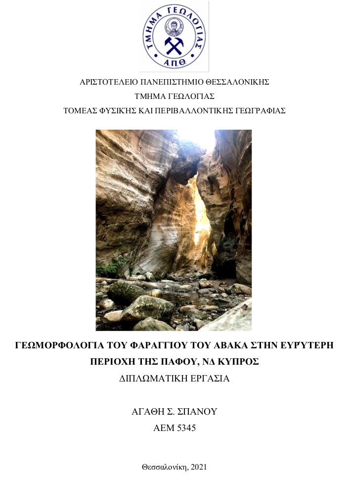
In this dissertation, the Avakas Gorge is studied, which is in the region of Pegeia, in the Akamas Peninsula where is located in the WSW Cyprus. The gorge extends and follows the Avgas River, from which it took its name. As a gorge is included of the NATURA 2000 network, due to its natural beauty.
The research focuses on the hydrographic network of the Avgas River, in which a fieldwork was carried out, in order to the geologically mapping of the significant points of interests and the imprinting them on the map. Primarily, data were collected, such as geological and topographic maps, bibliography, etc. about the area of Paphos, more precise about the area of Pegeia. Then, the geological, tectonic, and geomorphological data of the gorge area were recorded during the fieldwork study, and after that the geomorphological characteristics and the hydrographic network of the Avgas River were digitized with the use of ArcGIS software. Finally, according to the geomorphological results, a correlation of the Avgas River was carried out, both the processes and the form of the Avgas River, which led to various conclusions regarding the interaction of the hydrographic networks with their immediate environment.
Πλήρες Κείμενο:
PDFΑναφορές
Ξένη Βιβλιογραφία
Bashenina, N. V. (1978). Map of morpho and tectonomorpho- isohypses. Guide to Medium-scale Geomorphological Mapping. E. Schwerzerbart'sche Verlagsbuchhandlung, Stuttgart, 68-80.
Christian, C. L. (1958). Characterization of the" reactant"(gamma globulin factor) in the F II precipitin reaction and the F II tanned sheep cell agglutination test. The Journal of experimental medicine, 108(1), 139-157.
Demek, J. (1982). Geomorphological mapping: progress and problems. Perspectives in Geomorphology, 2, 221-235.
Gardiner, V. (1976). Land evaluation and the numerical delimitation of natural regions. Geographia Polonica, 34, 11-30.Speight, J. G. (1974). Parametric approach to landform regions.
Gass, I. G. (1960). The geology and mineral resources of the Dhali area. authority of the Government of Cyprus.
Horton, R. E. (1945). Erosional development of streams and their drainage basins; hydrophysical approach to quantitative morphology. Geological society of America bulletin, 56(3), 275-370.
Howard, J. A., and Mitchell, C. W. (1980). Phyto-geomorphic classification of the landscape. Geoforum, 11(2), 85-106.
Keller E.A, P., N. (2002). Active Tectonics, Earthquakes, Uplift and Landscape. USA: Second Edition.
Koeppen, W. (1936). Das geographische System der Klimate. Berlin: Handbuch der Klimatologie.
Mabbutt, J. A., and Stewart, G. A. (1963). The Application of Géomorphology in Resources Surveys in Australia, and New Guinea. Centre national de la recherche scientifique.
Malpas, J., Xenophontos, C., and Williams, D. (1992). The Ayia Varvara Formation of SW Cyprus: a product of complex collisional tectonics. Tectonophysics, 212(3-4), 193-211.
Malpas, J., Calon, T., and Squires, G. (1993). The development of a Late Cretaceous microplate suture zone in SW Cyprus. Geological Society, London, Special Publications, 76(1), 177-195.
Manzi, V., Lugli, S., Roveri, M., Pierre, F. D., Gennari, R., Lozar, F., ... & Turco, E. (2016). The Messinian salinity crisis in Cyprus: a further step towards a new stratigraphic framework for Eastern Mediterranean. Basin Research, 28(2), 207-236.
Mayer, L. (1990). Introduction to Quantitative Geomorphology: An Exercise Manual. Englewood Cliffs: NJ: Prentice Hall.
Miyogi, D., Sarkar, S.K., and Mallick, S. (1970). Geomorphic mapping in the plains of West Begnal, India, Selected Papers, Physical Geography, 1, pp 89-94, XXI International Geographical Congress, India 1968, National committee for geography, Calcutta.
Morisawa, M.E. (1964). Development of the drainage systems on an upraised lake floor. American Journal of Science.
Nikolayev, V. A. (1974). Principles of a landscape classification. Soviet Geography, 15(10), 654-661.
Robertson, A. H. F., & Hudson, J. D. (1974). Pelagic sediments in the Cretaceous and Tertiary history of the Troodos Massif, Cyprus. In Pelagic Sediments on Land and under the Sea (Vol. 1, pp. 403-436). Special Publication: International Association of Sedimentologists.
Robertson, A. H. F., & Woodcock, N. H. (1979). Mamonia Complex, southwest Cyprus: Evolution and emplacement of a Mesozoic continental margin. Geological Society of America Bulletin, 90(7), 651-665.
Robertson, A., and Xenophontos, C. (1993). Development of concepts concerning the Troodos ophiolite and adjacent units in Cyprus. Geological Society, London, Special Publications, 76(1), 85-119.
Robertson, A. H. F., Eaton, S., Follows, E. J., and Payne, A. S. (1995). Depositional processes and basin analysis of Messinian evaporites in Cyprus. Terra Nova, 7(2), 233-253.
Rossel F. (2001). Hydrometeorological study examining changes in recorded precipitation. Reassessment of the island’s water resources and demand. Objective 1 -
Output 1.2. Ministry of Agriculture, Natural Resources and Environment of the Republic of Cyprus Water Development Department, Food and Agriculture
Organisation of the United Nations Land and Water Development Division. TCP/CYP/8921.
Rotstein, Y., and Ben-Avraham, Z. (1985). Accretionary processes at subduction zones in the eastern Mediterranean. Tectonophysics, 112(1-4), 551-561.
Savigear, R. A. G. (1965). A technique of morphological mapping. Annals of the Association of American Geographers, 55(3), 514-538.
Schumm, S. (1956). The evolution of drainage systems and slopes in badlands at Perth Amboy. New Jersey: Bulletin of the Geological Society of America .
Scheidegger, A. E. (1965). The algebra of stream-order numbers. Washington, DC: US Geological Survey, Professional Paper B, 525.
Short, N. M., and Blair, R. W. (Eds.). (1986). Geomorphology from space: a global overview of regional landforms.
Stahler, A.H., and Strahler, A. (1998). Introducing Physical Geography.
STRAHLER , A. (1952). Hypsometric (area-altitude curve) analysis of erosional topography. Geological Society of America Bulletin.
Swarbrick, R. E., and Robertson, A. H. F. (1980). Revised stratigraphy of the Mesozoic rocks of southern Cyprus. Geological Magazine, 117(6), 547-563.
Vollmers, H. J. (1990). Examples for Using Sand and Lightweight Material in Movable Bed Models. In Movable Bed Physical Models (pp. 125-140). Springer, Dordrecht.
Wright, R. L. (1972). Principles in a geomorphological approach to land classification.
Ελληνική Βιβλιογραφία
Αστάρας, Θ. (1980). Ποσοτική γεωμορφολογική μελέτη τμήματος των δ. πλευρών του όρους Βερτίσκον (Κ. Μακεδονία) Διδακτορική διατριβή, Α.Π.Θ.,. Θεσσαλονίκη.
Αστάρας, Θ. (2011). Ψηφιακή χαρτογραφία και γεωγραφικά συστήματα πληροφοριών. Θεσσαλονίκη: Εκδόσεις Δίσιγμα, c2011.
Βαρνάβα, Α. (2016). Τεκτονική ανάλυση των ρηγμάτων της Γεράσας και του Αρακαπά στη ΝΔ Κύπρο. Μεταπτυχιακή Εργασία, Αριστοτέλειο Πανεπιστήμιο Θεσσαλονίκης.
Βουβαλίδης, Κ. (2011). Φυσική Γεωγραφία. Δίσιγμα.
Καρκάνας, Π., (2010). Εισαγωγή στην Γεωαρχαιολογία. Νεφέλη. Αθήνα
Κωνσταντίνου, Χ. (2010). Η Γεωλογική εξέλιξη της Κύπρου. Πτυχιακή Εργασία, Πανεπιστήμιο Πατρών.
Λαμπρινός , Ν. (2009). Φυσική Γεωγραφία και Περιβάλλον. Ανάκτηση από http://users.auth.gr/labrinos/books/PHYSGEO-students.pdf
Μπαλαφούτης Χ., και Μαχαίρας, Π. (1985). Μαθήματα γενικής κλιματολογίας: με στοιχεία βιοκλιματολογίας. Εκδόσεις ΓΙΑΧΟΥΔΗ Ο.Ε., Θεσσαλονίκη 1985.
Παυλόπουλος, Κ (2011). Γεωμορφολογία, εφαρμογές στις γεωεπιστήμες. Εκδόσεις Ιων, Αθήνα.
Πογιατζής, Λ. (2011). Υδρογεωλογική μελέτη της περιοχής Κίτι-Περβόλια, Κύπρος. Πτυχιακή Εργασία, Πανεπιστήμιο Πατρών.
Σμπόρας, Σ. (2005). Μορφοτεκτονική ανάλυση με τη χρήση γεωγραφικών συστημάτων πληροφοριών (GIS) των νεοτεκτονικών και ενεργών ρηγμάτων της Βοιωτίας. Θεσσαλονίκη. Ανάκτηση από https://www.researchgate.net/profile/Sotiris_Sboras/publication/233475110_ Morphotectonic_Analysis_using_Geographic_Information_Systems_GIS_of_Neotectonic_and_Active_Faults_of_Viotia_Central_Greece/links/594e180e45
Φουρνιάδης, Ι. (2002). Γεωμορφολογική και περιβαλλοντική εξέλιξη της κοιλάδας του Ανθεμούντα , με τη χρήση των μεθόδων GIS και τηλεπισκόπησης. Θεσσαλονίκη.
Χρυσάνθου, Β. 2015. Γεωμορφολογία Ποταμών. [Κεφάλαιο Συγγράμματος]. Στο Χρυσάνθου, Β. 2015. Ποτάμια υδραυλική και τεχνικά έργα. [ηλεκτρ. βιβλ.] Αθήνα:Σύνδεσμος Ελληνικών Ακαδημαϊκών Βιβλιοθηκών. κεφ 1. Διαθέσιμο στο: http://hdl.handle.net/11419/5434
Ψιλοβίκος, Α., και Ψιλοβίκος, Ά. (2010). Ιζηματολογία. Θεσσαλονίκη: Εκδόσεις Τζιόλα.
Πηγές Διαδικτύου
Αργυρόπουλος et al., 2004. Ανακτήθηκε από: http://www.moa.gov.cy/moa/wdd/wfd.nsf/All/D17AFEEBA8D505CFC22582C0002374C1/$file/Volume%201%20Greek.pdf?OpenElement
Κλίμα της Κύπρου, 2021. Ανακτήθηκε από: http://weather.cyi.ac.cy/el/%CE%BA%CE%BB%CE%B9%CE%BC%CE%B1/%CE%BA%CE%BB%CE%B9%CE%BC%CE%B1-%CF%84%CE%B7%CF%82-%CE%BA%CF%85%CF%80%CF%81%CE%BF%CF%85/)
Μονοπάτι Μελέτης της Φύσης «Φαράγγι του Άβακα». Ανακτήθηκε από: http://www.moa.gov.cy/moa/fd/fd.nsf/FF83F05EFF025E4BC2258108001B61DC/$file/%CE%9C%CE%BF%CE%BD%CE%BF%CF%80%CE%AC%CF%84%CE%B9%20%CE%A6%CE%B1%CF%81%CE%AC%CE%B3%CE%B3%CE%B9%20%CF%84%CE%BF%CF%85%20%CE%86%CE%B2%CE%B1%CE%BA%CE%B1.pdf
Μορφομετρικές Παράμετροι Λεκανών Απορροής. (n.d.). Ανάκτηση από http://www.geo.auth.gr/courses/gge/gge427y/pdf/askisi4.pdf?fbclid=IwAR1tx GsteLvheKaa4U_bwf-PIIZI3D2hq8TTEk6ujQRSKoZ2EkJ-FbzPJjI
Ποτάμια Υδραυλική Και Τεχνικά Έργα. (n.d.). Ανάκτηση από https://repository.kallipos.gr/bitstream/11419/5434/1/02_chapter_1.pdf?fbclid=IwAR0sU-ZZzkdSPA5UYhE8W9KkmLnfBExZ5TAiJzJn_HDZPi9KXuIQNa5p64s
Τμήμα Γεωλογικής Επισκόπησης Κύπρου, 2019. Ανακτήθηκε από: http://www.moa.gov.cy/moa/gsd/gsd.nsf/dmlindex_gr/dmlindex_gr?OpenDocument
Υπόγεια Υδατικά Σώματα, 2017. Ανακτήθηκε από: http://www.moa.gov.cy/moa/wdd/wdd.nsf/page57_gr/page57_gr?opendocument
ΒΙΒΛΙΟΓΡΑΦΙΑ
Αστάρας, Θ. (1980). Ποσοτική γεωμορφολογική μελέτη τμήματος των δ. πλευρών του όρους
Βερτίσκον (Κ. Μακεδονία) Διδακτορική διατριβή, Α.Π.Θ.,. Θεσσαλονίκη.
Βουβαλίδης, Κ. (2011). Φυσική Γεωγραφία. Δίσιγμα.
Δρ.Γ.Κωνσταντίνου(2002). «Η Γεωλογία της Κύπρου»
Ηλία, Π (2013). Διδακτορική διατριβή, «Η συμβολή της γεωμορφολογικής ανάλυσης στη μελέτη των υδρογραφικών δικτύων», Χαροκόπειο Πανεπιστήμιο,. Αθήνα.
Κωνσταντίνος Χ.(2010).Διπλωματική εργασία, , «Η γεωλογική εξέλιξη της Κύπρου»,Πανεπιστήμιο Πατρών.
Μονοπάτι Μελέτης της Φύσης-«Φαράγγι του Άβακα» www.moa.gov.cy/forest
Λαμπρινός , Ν. (2009). Φυσική Γεωγραφία και Περιβάλλον. Ανάκτηση από http://users.auth.gr/labrinos/books/PHYSGEO-students.pdf
Παπαπέτρου –Ζαμάνη, Α. (1995), Γεωμορφολογία, Αθήνα:Εκδόσεις Συμμετρία
Τμήμα Γεωλογικής Επισκόπησης. Τοπογραφικός χάρτης της Πέγειας κλίμακα 1:50.000 GEOLOGICAL MAP OF THE PEGEIA-STENI AREA
Υπουργείο Γεωργίας,Φυσικών Πόρων και Περιβάλλοντος- Τμήμα Δασών
Μάρης Π.Φώτιος . «Ποτάμια Υδραυλική και Τεχνικά έργα» Τμήμα Πολιτικών Μηχανικών.
Cyprus in your heart https://www.visitcyprus.com/index.php/el/
Google Earth. (Ιούνιος 2019). Google Earth. Ανάκτηση από https://www.google.com/intl/el/earth
Maroukian, Η., Gaki-Papanastassiou, K., Karymbalis, E., Vouvalidis, K., Pavlopoulos, K., Papanastassiou, D., & Albanakis, K. (2008). Morphotectonic control on drainage network evolution in the Perachora peninsula, Greece.
STRAHLER , A. (1952). Hypsometric (area-altitude curve) analysis of erosional topography. Geological Society of America Bulletin.
Εισερχόμενη Αναφορά
- Δεν υπάρχουν προς το παρόν εισερχόμενες αναφορές.