
Μελέτη της σεισμικής ακολουθίας στον ευρύτερο χώρο της Νισύρου το 2021 (Ιανουάριος – Οκτώβριος 2021) = A study of the seismic sequence in the border area of Nisyros in 2021 (Ianuary - Icriber 2021).
Περίληψη
Λέξεις Κλειδιά: Σεισμικότητα, σεισμική ακολουθία, ρήγμα, Νίσυρος, εστιακές συντεταγμένες, χωρική κατανομή, χωροχρονική κατανομή
The study of the seismicity in the area to determine the active structures is important for the reliable assessment of the seismic hazard and for the better prevention and preparation for the consequences of a future strong earthquake. This paper presents the study process of the seismic sequence that took place in the marine area southwest of Nisyros in 2021, from the collection, processing to the presentation of data and results in order to draw conclusions about the seismic area and the evolution of the sequence. The study area is located south-southwest of Nisyros and the data were collected from the Seismological Station of the University of Athens. for earthquakes that occurred in the region from January to October 2021. The processing of the data includes the determination of the focal coordinates which, in combination with additional data and parameters, will help to carry out a spatial and spatiotemporal distribution, in order to define the fault which is responsible for the seismic sequence, as well as the fault-type. The above information will provide a better understanding of the seismic sequence and seismic hazard in the region so that there is better prevention and preparation against a future strong earthquake.
Key words: Seismicity, seismic sequence, fault, Nisyros, focal coordinates, spatial distribution, spatiotemporal distribution
Πλήρες Κείμενο:
PDFΑναφορές
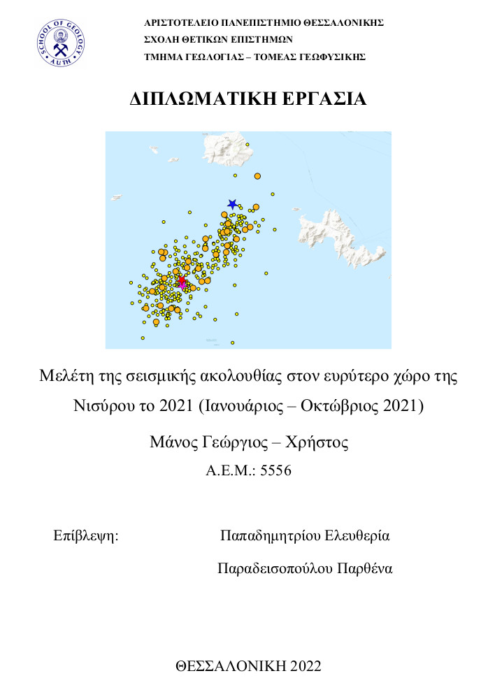
Για τη κατασκευή των χαρτών στη παρούσα εργασία, χρησιμοποιήθηκαν τα λογισμικά Generic Mapping Tools (GMT) των Wessel and Smith (1988) καθώς και το Quantum Geographic Information System (QGIS) του Gary Sherman (2002).
Aristotle University of Thessaloniki. (1981). Aristotle University of Thessaloniki Seismological Network [Data set]. International Federation of Digital Seismograph Networks. https://doi.org/10.7914/SN/HT
Akyol N., Zhu L., Mitchell B. J., Sοzbilir H., Kekovali K. (2006). Crustal structure and local seismicity in western Anatolia. Geophysical Journal International, 166(3), 1259–1269, https://doi.org/10.1111/j.1365-246X.2006.03053.x
Fytikas, M. and Kolios, N. (1979). Preliminary heat flow map of Greece. In Terrestrial Heat Flow in Europe, eds. V. Cermak and L. Rybach, 197-205, Springer-Verlag, Berlin
Φυτίκας Μ., Ανδρίτσος Ν. (2019). Γεωθερμία. Εκδόσεις Τζιόλα, 73-75.
H.U.S.N. (Hellenic Unified Seismological Network). 2021. http://geophysics.geo.auth.gr/ss/ (πρόσβαση 10/2021).
Hutton, L. K. and Boore, David M. (1987). The M_L scale in Southern California. Bulletin of the Seismological Society of America, 77 (6). 2074-2094.
Kissling, E., Ellsworth, W.-L., Eberhart-Phillips, D. & Kradolfer, U. (1994). Initial reference models in local earthquake tomography. J. Geophys. Res., 99(B10), 19 635–19 646.
Klein F. W., (2002). User's guide to HYPOINVERSE-2000, a Fortran program to solve for earthquake locations and magnitudes. U.S. Geological Survey. https://doi:10.3133/ofr02171
Kourouzidis, M. C., Karakaisis, G. F., Papazachos, B. C. and Makropoulos, C. (2004). Properties of Foreshocks and Aftershocks in the area of Greece. Proc. 10th International Congress of the Geological Society of Greece, 1422-1431.
Lee W. H. K., Lahr J. C., (1975). A computer program for the determining hypocenter, magnitude and first motion pattern of local earthquakes. U. S. Geol. Surv. Open File Report, 75-311.
McKenzie, D. P. (1970). Plate tectonics of the Mediterranean region. Nature, 226(5242), 239-243.
McKenzie, D. (1978). Active tectonics of the Alpine—Himalayan belt: the Aegean Sea and surrounding regions. Geophysical Journal International, 55(1), 217-254.
Papazachos B. C. (1971). Aftershock activity and aftershock risk in the area or Greece. Annals of Geophysics, 24(4), 439-456.
Papazachos, B. C. Dependence of the seismic parameter b on the magnitude range. PAGEOPH 112, 1059–1065 (1974b). https://doi.org/10.1007/BF00881508
Papazachos B., Polatou M. & Mandalos N. (1967). Dispersion of surface waves recorded in Athens. PAGEOPH 67, 95–106. https://doi.org/10.1007/BF00880566
Papazachos, B. C. and C. B. Papazachou (1989): The earthquakes of Greece. Ziti Publ. Thessaloniki, Greece, 356pp. (in Greek).
Papazachos B. C., Kiratzi, A. and Papadimitriou, E. (1991). Regional focal mechanisms for earthquakes in the Aegean area. Pure Appl. Geophys., 136, 405-420.
Papazachos, B. C. and Panagiotopoulos, D.G. (1993). Normal faults associated with volcanic activity and deep rupture zones in the southern Aegean volcanic arc, Tectonophysics, 220, 301-308
Papazachos B. C., Papadimitriou E. E., Kiratzi A. A., Papazachos C. B., Louvari E. K. (1998). Fault plane solutions in the Aegean Sea and the surrounding area and their tectonic implication. Bollettino di Geofisica ed Applicata, 39 (3), 199-218.
Παπαζάχος Β. Κ., Μουντράκης Δ. Μ., Παπαζάχος Κ. Β., Τρανός Μ. Δ., Καρακαΐσης Γ. Φ., Σαβαΐδης Α. Σ. (2001). Τα ρήγματα που προκάλεσαν τους γνωστούς ισχυρούς σεισμούς στην Ελλάδα από τον 5 ο αιώνα π.Χ. μέχρι και σήμερα. Πρακτ. 2 ο Συνέδριο Αντισεισμικής Μηχανικής και Τεχνικής Σεισμολογίας, Θεσσαλονίκη 28 – 30 Νοεμβρίου 2001, 2, 17-26.
Παπαζάχος, Β., Παπαζάχου, Κ. (2003). Οι Σεισμοί της Ελλάδας. Εκδόσεις Ζήτη , 14-17, 70, 67-96.
Papazachos, B. C., Scordilis, E. M., Panagiotopoulos, D. G., Papazachos, C. B. and Karakaisis, G. F. (2004). Global relations between seismic fault parameters and moment magnitude of earthquake. Proc. 10th International Congress of the Geological Society of Greece, 1482-1489.
Wessel, P., Smith, W. H. F., Scharroo, R., Luis, J. F. and Wobbe, F. (2013). Generic Mapping Tools: Improved version released. EOS Trans AGU 94, 409-410. doi:10.1002/2013EO450001.
Ιστοσελίδες
http://www.geophysics.geo.auth.gr - Τομέας Γεωφυσικής Α.Π.Θ.
https://bbnet.gein.noa.gr - Εθνικό Αστεροσκοπείο Αθηνών (Ν.Ο.Α.).
Εισερχόμενη Αναφορά
- Δεν υπάρχουν προς το παρόν εισερχόμενες αναφορές.