
Εφαρμογή της ηλεκτρικής τομογραφίας για τον εντοπισμό λειψάνων θαμμένου δρόμου = Application of electrical tomography for location remains of buried road
Περίληψη
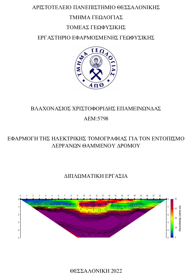
In this work, the geophysical method of electrical tomography is used in order to identify buried road remains. Initially, an introduction and analysis of the basic principles of the method of electrical tomography is made. Following, a description of the area where the specific survey took place and the methodology used to locate, collect and process the data is described. The last chapter sets out the conclusions drawn from the study of this work. In general, the data were subjected to special processing and images of the subsurface electrical in two dimensions were produced. The images typically depict a relatively superficial resistive anomaly that is interpreted as a structure of archaeological interest. As measurements were made in successive parallel sections it was possible to correlate the results and jointly interpret the geoelectrical images. The correlation verifies the presence of a linear geoelectrical structure that could be attributed to a potentially ancient road.
Πλήρες Κείμενο:
PDFΑναφορές
• Aspinall A, Gaffney CF. 2001. The Schlumberger array-potential and pitfalls in archaeological prospection. Archaeological Prospection 8: 199–209.
• Athanasiou E, Tsourlos PI, Vargemezis GN, Papazachos CB, Tsokas GN. 2007. Nondestructive DC resistivity surveying using flat base electrodes. Near Surface Geophysics 5(4): 263–272.
• Chouker F. 2001. Archaeological site investigation by geoelectrical measurements in Tel-Halawi (northern Syria). Archaeological Prospection 8: 257–263.
• Clark A. 1990. Seeing Beneath the Soil-Prospecting Methods in Archaeology. B.T. Batsford: London.
• Edwards, W., Okita, M., Goodman, D., 2000. Investigation of Subterranean Tomb in Miyazaki, Japan. Archaeological Prospection 7, 215–224.
• https://earth.google.com/web/@0,0,0a,22251752.77375655d,35y,0h,0t,0r
• Γραβάλας Τριαντάφυλλος, Θεσσαλονίκη 2021. Διερεύνηση εδαφικών ρωγμώσεων με γεωφυσικές μεθόδους. Μεταπτυχιακή διπλωματική εργασία.
• Griffiths, D., Barker, R., 1993. Two dimensional resistivity imaging and modeling in areas of complex geology. Journal of Applied Geophysics 19, 211–226.
• Γρηγοριάδης Αλέξανδρος, Χανιά, Δεκέμβριος 2016. Γεωηλεκτρική γεωφυσική διασκόπηση για την κατασκευή λιμνοδεξαμενής στο οροπέδιο Ασκύφου Χανίων.
• http://canyoning-caving.blogspot.com/2019/12/blog-post.html
• https://el.wikipedia.org/wiki/%CE%91%CE%B4%CF%81%CE%B9%CE%B1%CF%84%CE%B9%CE%BA%CE%AE_%CE%98%CE%AC%CE%BB%CE%B1%CF%83%CF%83%CE%B1
• https://el.wikipedia.org/wiki/%CE%A0%CE%B1%CE%BB%CE%B1%CE%B9%CE%BF%CE%BA%CF%8E%CE%BC%CE%B7_%CE%A3%CE%B5%CF%81%CF%81%CF%8E%CE%BD
• https://historylink101.com/2/Rome/roman-roads.htm
• http://odysseus.culture.gr/h/2/gh251.jsp?obj_id=21706
• https://www.goldensoftware.com/products/surfer/features
• https://www.xronometro.com/amfpolis-egnatia/
• https://www.xronometro.com/amfipolis-sparagmata/
• Kaimaris D., Geogoula O., Karadedos G., Patias P., 2011. The marks of ancient Via Egnatia in aerial photographs and satellite images: En Choro Techniessa: Volume in honor to Prof. Skarpia-Heupel.
• Kim, Y.H., 2011. DC2Dpro – User's Manual, KIGAM, Daejon, Korea.
• Κακλής Τριαντάφυλλος, Θεσσαλονίκη 2011. ΥΔΡΟΓΕΩΛΟΓΙΚΗ ΜΕΛΕΤΗ ΔΙΑΧΕΙΡΗΣΗΣ ΥΔΑΤΙΝΩΝ ΠΟΡΩΝ ΠΙΕΡΙΑΣ ΛΕΚΑΝΗΣ Ν.ΚΑΒΑΛΑΣ.
• Μουντράκης Δ. 1994. Εισαγωγή στην γεωλογία της Μακεδονίας και Θράκης. Απόψεις για την γεωτεκτονική εξέλιξη της Ελληνικής Ενδοχώρας και των Εσωτερικών Ελληνίδων. Δελτ. Ελλ. Γεωλ. Ετ., 30-46.
• Νιβορλής Αριστείδης, Θεσσαλονίκη. ΕΦΑΡΜΟΓΗ ΤΗΣ ΜΕΘΟΔΟΥ ΤΗΣ ΤΡΙΣΔΙΑΣΤΑΤΗΣ ΗΛΕΚΤΡΙΚΗΣ ΤΟΜΟΓΡΑΦΙΑΣ ΣΤΟΝ ΕΝΤΟΠΙΣΜΟ ΘΑΜΜΕΝΩΝ ΑΡΧΑΙΟΤΗΤΩΝ. Διπλωματική εργασία.
• Παπαζάχος Βασίλειος, Θεσσαλονίκη 1996. Εισαγωγή στην Εφαρμοσμένη Γεωφυσική. Εκδόσεις ΖΗΤΗ.
• Παπαζάχος Βασίλειος, Παπαζάχος Κωνσταντίνος, 2η έκδοση Δεκέμβριος 2013. Εισαγωγή στη Γεωφυσική. Εκδόσεις ΖΗΤΗ, Θεσσαλονίκη.
• Τσελέντης Άκης, Παρασκευόπουλος Π., Αθήνα 2013. Εφαρμοσμένη Γεωφυσική. Εκδόσεις Liberal Books.
• Tsokas, G.N., Rocca, A.Ch., 1987. Field investigation of a Macedonian tumulus by resistivity soundings. Geoexploration 24, 99–108.
• Tsokas, G.N., Tsourlos, P.I., Stampolidis A., Katsanopoulou D., Soter S. Tracing a Major Roman Road in the Area of Ancient Helike by Resistivity Tomography. 22 June 2009.
• Tsourlos, P., 1995. Modelling interpretation and inversion of multielectrode resistivity survey data. Ph.D. Thesis, University of York.
Εισερχόμενη Αναφορά
- Δεν υπάρχουν προς το παρόν εισερχόμενες αναφορές.